Spatial Tools
Gateway URL: https://gateway.vectorsurv.org/core/ppf/menu/path/82
Use these tools to help manage spatial aspects of your data.
Geocode
This tool will extract long/lat coordinates from an address typed into the Location field or uploaded in a file, which is advantageous for geocoding multiple addresses at once. Note that the geocode file must follow a specific format for the import to be successful, which can be found at the box to the right-hand side of the screen. This feature is also available when adding a new site by its address.
Additional resource: YouTube tutorial for Geocode addresses.
Spatial Features
Saved spatial features are useful for filtering within an agency for output/export files. Get started by clicking on “New Feature”, then “Add Polygon”. Click on the map to add as many vertices as necessary. Name the feature and tick the boxes for the appropriate sharing settings. You can save the feature by clicking on “Save Feature” or “Save Feature As” to use it for data visualization.
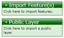
You can also directly import features saved from another mapping software using the boxes to the right. Importing a feature as a public layer means that it will be available to be included on public-facing maps that may be developed in the future.
If you are looking to add or update the primary spatial representation of your agency’s boundaries as it appears on the public-facing maps, contact the VectorSurv team directly at help@vectorsurv.org.
Additional resource: YouTube tutorial for Spatial Features.
VectorSurv Maps
This is a link to VectorSurv Maps
Additional resource: YouTube tutorial for VectorSurv Maps.